Bitte ändert euer Passwort!
Im März 2026 wurde das Forum gehackt. Dabei hatten die Angreifer Zugriff auf die Datenbank und somit Zugriff auf eure Passwörter. Auch wenn das Forum kein Passwort im Klartext speichert, können die Angreifer eure Passwörter knacken. Bitte ändert daher dringend euer Passwort für das Forum. Solltet ihr das gleiche Passwort auch an anderer Stelle verwenden, ändert es bitte unbedingt an allen Stellen!
GPS data conversion for maps
- skyfreak
- Offline
- Platinum Mitglied
-

- Beiträge: 2947
- Thanks: 1450
Re: GPS data conversion for maps
05 Apr. 2016 20:39a keyfeature of the Telemetrie Analyzer according to
www.drangzumhang.de/telemetrie-analyzer-fuer-jeti-log/
ok, not mac like as you need windows and Microsoft .NET Framework 4.0 installed, but at least a way that should visualize your gps data.
maybe it can export too? that at least you could anaylze your flight on the mac in google maps.
looks like the Data Explorer can handle GPS data as well.
www.nongnu.org/dataexplorer/
GUIDO
_________________________________________________________
Too many dicks on the dance floor.
Too many dicks!
Bitte Anmelden oder Registrieren um der Konversation beizutreten.
- skyfreak
- Offline
- Platinum Mitglied
-
- Beiträge: 2947
- Thanks: 1450
Re: GPS data conversion for maps
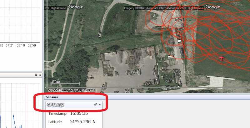
05 Apr. 2016 20:43 - 05 Apr. 2016 20:43Dataexplorer - import log file - export as KMZ 3D - and bang just opened it in google earth.
all on mac!
so here is ONE solution to your problem
www.nongnu.org/dataexplorer/index.html
have fun and enjoy your flights on the mac

GUIDO
_________________________________________________________
Too many dicks on the dance floor.
Too many dicks!
Bitte Anmelden oder Registrieren um der Konversation beizutreten.
- Didier
- Autor
- Offline
- Senior Mitglied
-

- Beiträge: 46
- Thanks: 7
Re: GPS data conversion for maps
05 Apr. 2016 20:47I will explore it tomorrow as I have to work very early tomorrow.
I will let you know!
Thanks again!
")
Bitte Anmelden oder Registrieren um der Konversation beizutreten.
- Didier
- Autor
- Offline
- Senior Mitglied
-
- Beiträge: 46
- Thanks: 7
Re: GPS data conversion for maps
06 Apr. 2016 07:55skyfreak wrote: touchdown workz !!!
Dataexplorer - import log file - export as KMZ 3D - and bang just opened it in google earth.
all on mac!
so here is ONE solution to your problem
www.nongnu.org/dataexplorer/index.html
have fun and enjoy your flights on the mac
Hello Guido,
I am not a computer expert, that's why I have a Mac.
")
Some how "data explorer" doesn't seems to work on my Mac. It says: application is damaged and needs to be closed".
I re-installed the 64 bit software, but nothing works.
Is there a step-by step description how to get "data explorer" working on a Mac?
I'm thinking to buy a small Windows 10 laptop, as "Jeti flight monitor" and several other programs doesn't work on my "old" windows XP laptop as well.
Once again many thanks!
Bitte Anmelden oder Registrieren um der Konversation beizutreten.
- NicoS
-
- Offline
- Platinum Mitglied
-
- Beiträge: 489
- Thanks: 146
Re: GPS data conversion for maps
06 Apr. 2016 09:29 - 06 Apr. 2016 10:04But there is another problem....
I have a look in your logffile. The data send bij the GPS is not 100% compatible with the data sent by a JETI MGPS EX GPS sensor. The Jeti Flight Monitor do not show the flightpad and the Google Earth map. I have test it with your logfile.
I have the SM-modellbau GPS-logger 2. Same problem. Data not 100% compatible with te Jeti MGPS-EX and the Jeti Flight Monitor show not the flightpad and the map.
I have write a small program for correcting the logfile with the GPS-logger 2 data. Now the Jeti Flight Monitor show the flightpad and the map.
With greetings,
Nico
Bitte Anmelden oder Registrieren um der Konversation beizutreten.
- skyfreak
- Offline
- Platinum Mitglied
-
- Beiträge: 2947
- Thanks: 1450
Re: GPS data conversion for maps
06 Apr. 2016 12:17I run java-8 update 77 and dataexplorer 3.2.5 without any porblems on my mac 10.10.5.
difficult to help just via the thread here, but if ya cannot get it to run at all, we might communicate 1:1 b e.g. skype-voip and if ya share your screen with me I could at least see and guide you. I am a big fan of the data explorer, there is as well an extra subforum here witha mod in direct contact to the developer. I analyze all my data with it, althogh I must admit, that I haven't used GPS data for a long time (more than 1.5 years) and than again as mentioned, I took the datafile directly from my gps logger sd card.
regarding the gps data of your logfile, respectively the way and format the data is saved via jeti ex protocol to the jeti sd card ...
I haven't checked the quality of the data, just exported it from dataexplorer and checked that I could open the export file in google earth.
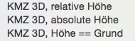
am pretty busy atm. for further tests I attached a zip file containing
- yr original log
- 3 exports with DataExplorer as it offers 3 options
rgds,
guido
GUIDO
_________________________________________________________
Too many dicks on the dance floor.
Too many dicks!
Bitte Anmelden oder Registrieren um der Konversation beizutreten.